Address : Observatoire de Meudon, 5 Place Jules Janssen, F-92 195 Meudon Cedex
Tel : 00 33 (0)1.45.07.75.30
Fax : 00 33 (0)1.45.07.74.69
There are many ways to come to the Observatory which is located in the city of Meudon, south-west of Paris. We give here some useful indications.
If you don't find what you are looking for, please contact us.
- We foresee a bus pick up at the "meudon-bellevue" and "Val-Fleury" stations, but this has to be confirmed.
- For an interactive map, look at the one created by Christian: [ Google Map ].
- For a printer friendly summary, check this [ file ] (pdf)
- Driving directions to Meudon
- From Roissy CDG airport to Meudon [ general ],
[ zoom ]
- From Orly airport to Meudon [ general ],
[ zoom ]
- From Paris to Meudon, 2 ways (also see zoom maps above): take the ring ("peripherique") and exit at "Quai d'Issy", follow the directions "Issy les Moulineaux", then "Sevres" and "Meudon"
OR take the road N118 from the "Pont de Sevres", follow the direction "Chartres Orleans", exit at "Meudon-Chaville", then follow "Meudon-centre".
- How to go from the airport (Orly or CDG) to Paris
- The web site dedicated to Paris airports gives all the directions wether you want to use public transports, taxi or your car. Just follow this
link. Prefer the RER-B train if you want to go to montparnasse area.
- Trains from Paris to Meudon (4 possible stops: look at this map)
- [ recommended ] From Montparnasse railway station in Paris, look for the suburban trains ("transilien" in french) and take the one going to "Sevres Rive Gauche"
or possibly the one going to "Versailles-Chantiers" (but make sure on the platform that the stop "bellevue" is listed). "Bellevue" is the 4th stop
(after "Vanves-Malakoff", "Clamart" and "Meudon"). On your left, when leaving the station, take the "avenue du chateau" which has a uniform gentle slope compared to other ways. The entrance of the Observatory is at the end
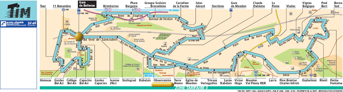
of the avenue. The Meudon city bus TIM also runs once an hour from the station to the Observatory.[ map ]
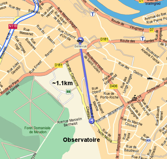
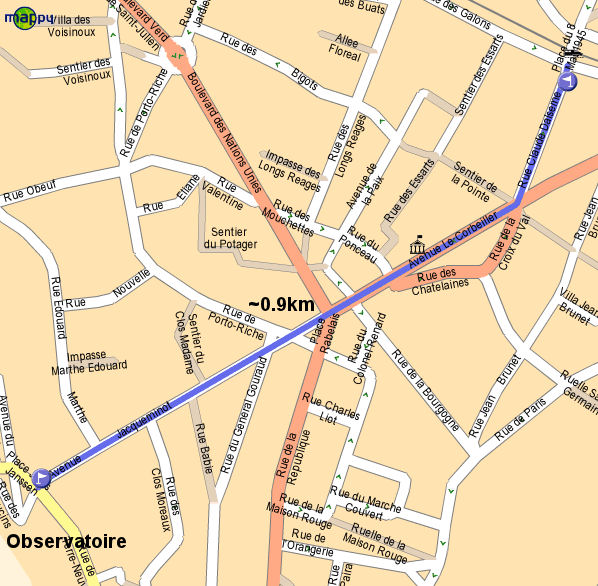
- With the same train from Montparnasse, you can also choose to stop at "meudon". Then walk on your right for
200m ("rue Claude Dalseme"), turn right again ("avenue le Corbeiller") and walk straight to the top of the hill ("avenue Jacqueminot"). Beware of the rather steep slope. No pick-up at this station. [ map ]
-
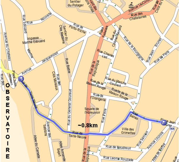
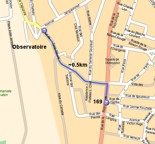
The RER C line : take the trains RER-C going to "Versailles Rive Gauche" and stop at "Meudon-Val Fleury". When leaving the station follow the "rue banes", turn left in the "rue de paris" then turn right and go straigth to the Observatory.
This way is the shorter in distance from the 3 train stations but the slope is rather steep. [ map ]
- Underground ("metro") + bus:
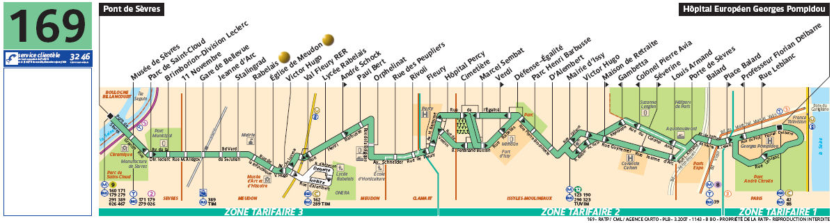
Take metro line number 12 ("Porte de la Chapelle" to "Mairie d'Issy"). At "Mairie d'Issy" take the bus 169 going to "Pont de Sevres" and stop at "Place Rabelais" or "Eglise de Meudon" (no pick-up). [ map ]
- NEW Train schedule from Montparnasse to Bellevue
- Preliminary bus schedule (departures), to be confirmed
| | Bellevue | Val-Fleury | Observatory |
| 17/01 | 12h30 | 12h50 | 18h30 |
| 18/01 | 8h50 | 9h10 | 18h30 |
| 19/01 | 8h50 | 9h10 | 12h30 |
- These maps could be helpful
- Meudon Observatory [ map ]
- Railway and RER global [ map ] (pdf)
- Metro and RER global [ map ] (pdf)
- Bus in Paris global [ map ] (pdf)
- This link leads you to the interactive map
- and this one to the main city transportation web site (RATP)
- Other informations
- The Observatory is the highest location in Meudon, so, whatever direction you are coming from, you need to climb.
- Once you arrived just ask the door keeper or follow the signals to find your way.
- If you're coming by car you can park within the Observatory.
- The ticket price from Paris to Meudon is about 2.10€ (train or RER)
![[ general ]](images/CDG2MEUDON.jpg)
![[ zoom ]](images/CDG2MEUDON2.jpg)
![[ general ]](images/ORLY2MEUDON.jpg)
![[ zoom ]](images/ORLY2MEUDON2.jpg)
![[ Montparnasse to Bellevue ]](images/m2b17.jpg)
![[ Bellevue to Montparnasse ]](images/b2m17.jpg)
![[ Montparnasse to Bellevue ]](images/m2b18.jpg)
![[ Bellevue to Montparnasse ]](images/b2m18.jpg)
![[ Montparnasse to Bellevue ]](images/m2b19.jpg)
![[ Bellevue to Montparnasse ]](images/b2m19.jpg)
![[ map ]](images/observatoire.jpg)